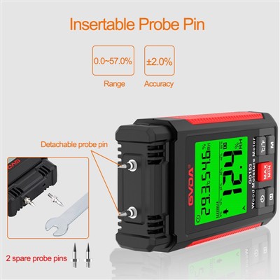
Distance measurement, the most used function in archaeology. The following two examples are used to illustrate: 1. In the process of drawing the plan and section drawings of the tomb, the length, width and height of the tomb should be measured and registered, and then drawn according to the scale. It is assumed that the tomb is a vertical pit tomb, and the bottom of the mouth is the same size. If you want to measure the width of the tomb, set the handheld laser range finder (Hilti PD42) to start from the bottom of the instrument, then put the bottom of the handheld laser range finder against the tomb wall, hold the horizontal button, and then the tomb width data will be displayed. will be displayed on the screen. The length measurement is similar to the width. The depth measurement can be measured directly from the tomb mouth down, and a target board is also placed at the tomb mouth, so that it can be measured upwards from the bottom of the tomb, and the effect is the same. If the mouth and bottom of the tomb are different, in order to prevent the influence of the inclined tomb wall, an extension rod can be used for time-lapse measurement. 2. Measurement of sealing mound. Set the handheld laser rangefinder to triangulation mode, and then take the handheld laser rangefinder as the vertex (preferably horizontal to the bottom of the mound), and measure the distances to the bottom and top of the mound respectively, then the height of the mound will be at It is automatically solved and displayed in the instrument. This function is especially useful in the wild. In the survey of the Great Wall resources, some beacon towers cannot be climbed up or are difficult to approach, and this function can be used to measure the height of the beacon towers; in the third national cultural relics census, some ancient buildings, stone carvings etc. are also inaccessible and can also be measured using this function.
Area and volume measurements are also widely used in archaeology. For example, the area of exploration, the opening area of the tomb, the area of the city site, the earthwork of the exploration, the earthwork of the tomb, etc. To achieve these functions, you only need to switch the function options of the handheld laser rangefinder to the corresponding options, and then measure two or three data of the entity to obtain the area and volume data. As for the stakeout function of the handheld laser rangefinder, I won't go into details here, because the stakeout function of the total station and GPS-RTK is much more powerful than it.