Application of laser rangefinder in the forestry industry
Data collection is used for forestry resource inventory, including tree height, height that can be used for commercial purposes, vegetation mapping, positioning of wild special and excellent tree species, determining the grade and economic value of trees in the area, or determining the location of trees at specific heights during cultivation and management research, such as pruning, drawing a logging volume profile map, and determining resource boundaries; When considering the method of bundling and stacking timber for harvesting timber, it is very important to measure and map the terrain of the bundling and stacking timber channel, as well as conduct pre construction survey of roads and rugged paths for general purposes. Using conventional surveys, aerial photography, and GPS positioning that were previously available may encounter various issues (such as cost, accuracy, obstacles, etc.).
Field data collection is a long-standing problem that has plagued surveyors, cartographers, GIS database managers, engineers, and researchers. The problem is simple: how to efficiently and accurately collect location and physical feature data for mapping, cataloging, resource inventory, and database storage.
Finding the result of this problem in a given situation can be frustrating. Because:
(1) There may be many methods and techniques that can be used;
(2) In the vast majority of cases, there is no single method that can provide complete and satisfactory results.
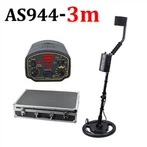
The application of laser technology, especially the laser rangefinder developed by Laser Technology Corporation (LTI) in the United States, has been increasingly improved since 1990 when it was used as a field measurement prototype by the US Department of Agriculture and Forestry Bureau for evaluation of its future development applications. It can be connected to data collectors and GPS, and can be configured with various software. This has propelled forestry measurement from manual compasses, ropes, inclinometers, and old-fashioned telescopes to the era of single person operation, full station, and comprehensive multi-purpose instruments.
The measurement system designed by LTI is suitable for basic vegetation resources and wood sales inspections and planning measurements, as well as logging volume distribution maps and road survey measurements. By June 1993, the US Forestry Administration had purchased over 150 of these instruments. In the field planning and use by the US Department of Agriculture and Forestry, this laser rangefinder not only has complete functionality, accuracy, and durability, but also saves costs, especially in areas where the target is unclear. This is evidenced by the shrublands in northern Idaho and the rainforests in southeastern Alaska.
China, with vast resources, has abundant forestry resources. With the large-scale production brought about by the reform and opening up, the important position of forestry in the national economy has become increasingly prominent, and the demand for commercial timber has surged. How to plan the development of forestry, measure forestry resources with higher accuracy, and focus on safer forestry resource inventory and cataloging with wood sales has become an important issue for the forestry department. Introducing laser measurement technology will help promote China's forestry measurement technology into a new era.