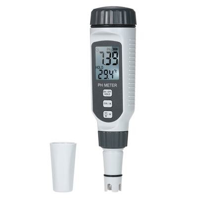
Application of handheld laser rangefinder in archaeological research
At present, instruments such as tape measure, steel tape measure, GPS, and total station are widely used in field archaeology to measure length, area, volume, etc., and total station, GPS-RTK, etc. are used for terrain surveying, survey layout, and engineering stakeout. So, what can a handheld laser rangefinder do? The handheld laser rangefinder can also achieve functions such as measuring distance, area, volume, and setting out with a theodolite.
Distance measurement, the most used function in archeology. Here are two examples: 1. In the process of drawing the plan and cross-section of the tomb, the length, width and height of the tomb must be measured and registered, and then drawn according to the scale. It is assumed that the tomb is an earth pit tomb with a vertical pit, and the mouth and bottom are the same size. If you want to measure the width of the tomb, set the handheld laser rangefinder (Hilti PD42) to start from the bottom of the instrument, then place the bottom of the handheld laser rangefinder against the tomb wall, keep the button horizontal, and then the tomb width data will be will be displayed on the screen. Length measurement is similar to width. Depth measurement can be measured directly from the entrance of the tomb downwards. A target board is also placed at the entrance of the tomb and then measured from the bottom of the tomb upwards. The effect is the same. If the bottom of the tomb mouth is different, in order to prevent the influence of the tilted tomb wall, an extension rod can be used to perform delayed measurement. 2. Measurement of the sealing pile. Set the handheld laser rangefinder to triangulation mode, and then use the handheld laser rangefinder as the vertex (level with the bottom of the soil pile) to measure the distance to the bottom and top of the soil pile. Then, the height of the soil pile will be in the instrument. Automatically solved and displayed. This function is especially practical in the wild. In the Great Wall resource survey, some beacon towers cannot be climbed or are difficult to access, so you can use this function to measure the height of the beacon towers; in the third national cultural relics census, some ancient buildings and stone carvings etc. are also difficult to access and can also be measured using this function.
Area and volume measurements are also widely used in archaeology. For example, the exploration area, the tomb opening area, the city site area, the exploration earthwork, the burial earthwork, etc. To realize these functions, you only need to switch the function option of the handheld laser rangefinder to the corresponding option, and then measure two to three data of the entity to obtain the area and volume data. As for the lofting function of the handheld laser rangefinder, I will not go into details here, because the lofting function of the total station and GPS-RTK is much more powerful than it.